


From the panoramic views at High Point State Park to the salt marshes of Galloway, New Jersey’s 4,500 miles of trails are an inspiring source of family fun. The Garden State has some of the best kid-friendly and accessible trails, for everything from bird watching to learning about Revolutionary War history. This sampling of hikes reaches every corner of the state and offers a range of diverse ecosystems. Put the phones and tablets away; grab the sunscreen, insect repellent, and a good walking stick—and go take a hike!
Taking it From the Top
High Point State Park, Sussex, Monument Trail Loop
Rating: Moderate
Distance: 3.5-mile loop
Elevation gain: 515 ft.
Accessibility: The Monument Trail Loop is rocky and uneven. The path around the monument and first floor are wheelchair-accessible.
Welcome to the highest point in the Garden State! There aren’t many hiking trails that reward hikers with gorgeous panoramic views of three states and three mountain ranges, but the Monument Trail Loop at High Point State Park is one of them.
The Monument Trail Loop begins and ends at the summit parking lot beside the 220-foot monument built in 1930 to honor all war veterans. Here, visitors can take in 360-degree views of New Jersey, New York, and Pennsylvania, or climb the 291 steps inside the obelisk to reach the highest elevation in the state. The entrance to the Monument Trail Loop begins at the opposite end of the parking lot from the monument. Along the trail, which is moderately rocky with slight elevation changes, hikers will see Lake Marcia and experience the world’s highest Atlantic white cedar freshwater swamp. Other trees along the trails include red oak, maple, hemlock, black birch, and black gum trees. In the spring, there are irises, callas, and rhododendrons.
While the Monument Trail Loop is not wheelchair-accessible, visitors can drive to the summit where there is accessible parking; the first floor of the monument is wheelchair-accessible.

The Family-Friendliest
Rating: Easy
Distance: 4.9-mile loop
Elevation gain: 496 ft.
Accessible: The paths are paved and wheelchair-accessible. Additionally, an accessibility shuttle, which is not a tour, can be reserved on its website.
With more than 20 miles of trails winding around woods, meadows, and lakes, Duke Farms is ideal for first-time hikers and families. Once the home of James Buchanan Duke and later his daughter, Doris, the 2,700 acres comprising Duke Farms’ nature preserve is operated by the Doris Duke Foundation.
Duke Farms is a wonderful place for children and families to explore and experience nature, with more than 500 species of plants and more than 300 species of birds on the preserve. The 5 miles of paved trails are perfect for strollers, bikes, wheelchairs, and those with limited mobility.
In the spring, vibrant native wildflowers make this hike especially scenic. There is also an Orchid Range, which is a greenhouse with subtropical and tropical orchids on display inside. Behind the Farm Barn in the grasslands, visitors may spot beautiful birds up close. A pair of Bald Eagles lives in a nest in a sycamore tree on the property and the website has an eagle cam. Other birds include the American Kestrel, which is threatened, and the Northern Harrier, which is endangered. Duke Farms is also home to the Farm Barn Café, which serves nutritious, locally sourced meals.

History Meets Nature
Sandy Hook Gateway National Recreation Area, Sandy Hook
Rating: Moderate
Distance: 10 miles
Elevation gain: 85 ft.
Accessibility: Paved trails and areas mentioned below are wheelchair-accessible. Beach wheelchairs are available for loan by calling The Sandy Hook Visitor Center in advance at 732-872-5970.
A strategic location since the Revolutionary War, Sandy Hook is a hiking destination where U.S. history, diverse ecosystems, and abundant wildlife come together for some of the most unique trails in New Jersey. There are also impressive views of the Manhattan skyline!
The deep waters surrounding the peninsula have provided ships with the best entry to New York Harbor since the early days of water travel, which is why it’s no surprise that Sandy Hook is home to the oldest operating lighthouse in the U.S. Its strategic location also made it valuable to the British Army during the Revolutionary War. Later, it became home to Fort Hancock, which operated from 1895 to 1974 and was integral to national defense.
Hikers can also see Officers’ Row, the 18 houses built for officers and their families around the turn of the 19th century. There are several trails, including the Old Dune Trail and South Beach Dune Trail, but the most family-friendly and accessible is the fully-paved Multi-Use Pathway (MUP), which begins at the park entrance and continues for 5 miles to Fort Hancock. There, hikers can visit the lighthouse and the adjacent Sandy Hook Visitor Center located in the Lighthouse Keepers Quarters.
The park boasts the world’s largest holly forest ecosystem and abundant wildlife. There are more than 325 bird species, along with mammals such as white-tailed deer, foxes, raccoons, harbor seals, and muskrats. There are also several types of turtles and gray tree frogs—not to mention the ocean life in and around the sandy beaches.
The Junior Ranger program at Sandy Hook, part of the Gateway National Recreation Area, offers kids ages 7-14 a chance to learn about the importance of preserving and protecting national parks through hands-on activities. Kids can pick up a Junior Ranger Booklet at the Sandy Hook Visitor Center and complete it to receive a Junior Ranger badge.
The Lighthouse Keepers Quarters, the Barn, beach concession stands, several parking lots and Guardian Park are all wheelchair-accessible. All six beach centers have wheelchair-accessible bathrooms as well. For information about beach wheelchairs available for loan, call the Sandy Hook Visitor Center in advance at 732-872-5970.

Small but Mighty
Rating: Moderate
Distance: 5.1-mile perimeter trail (1.1-mile cove trail, easy)
Elevation gain: 250 ft.
Accessibility: The gravel perimeter trail is mostly flat. It’s good for hiking and biking but visitors in wheelchairs, strollers, or mobility equipment may need all-terrain tires or adaptive/motorized equipment. The cove trail is for pedestrians only and is not wheelchair-accessible.
Lake views, learning, and birding! Hikers can pack a lot into a day trip to the 770-acre Manasquan Reservoir without being overwhelmed. Osprey, hawks, ducks, and nesting Bald Eagles are just some of the wildlife that make the reservoir their home.
Start at the Manasquan Reservoir Visitor Center to reach two of the main trails. The 5.1-mile Perimeter Trail offers the best water views and loops around the reservoir, which reaches depths of 40 feet and is popular with boaters. The wide gravel path is mostly flat and suitable for walking, running, or biking. If you’re looking for a shorter hike, the Cove Trail is a narrower path that veers away from the reservoir and winds through the swamps along Timber Swamp Brook. It’s a great spot to look for frogs and toads. Be sure to visit the Environmental Center, which offers interactive exhibits that both kids and adults can enjoy. There are a few live animals, multimedia presentations, wildlife observation areas, and wildlife educational activities. Tours can also be scheduled. While there, check out the light-up display that demonstrates how the reservoir, holding 4 billion gallons of water, gets filled. The reservoir is a water source for surrounding towns and utilities.
The Visitor Center, which is separate from the Environmental Center, has boat rentals, vending machines, restrooms, and a second-floor observation deck. Nearby is a wildlife-themed playground and, for those who plan to bike as well as hike, there’s a bike repair station and air pump.
Clap if You Believe in Fairies!
South Mountain Reservation, West Orange, Millburn and Maplewood
Hemlock Falls Loop, including Fairy Trail
Rating: Moderate
Distance: 5.9 miles
Elevation gain: 764 ft.
Accessibility: The dirt trails are uneven with roots and rocks. There are some footbridges but the trails are not wheelchair-accessible.
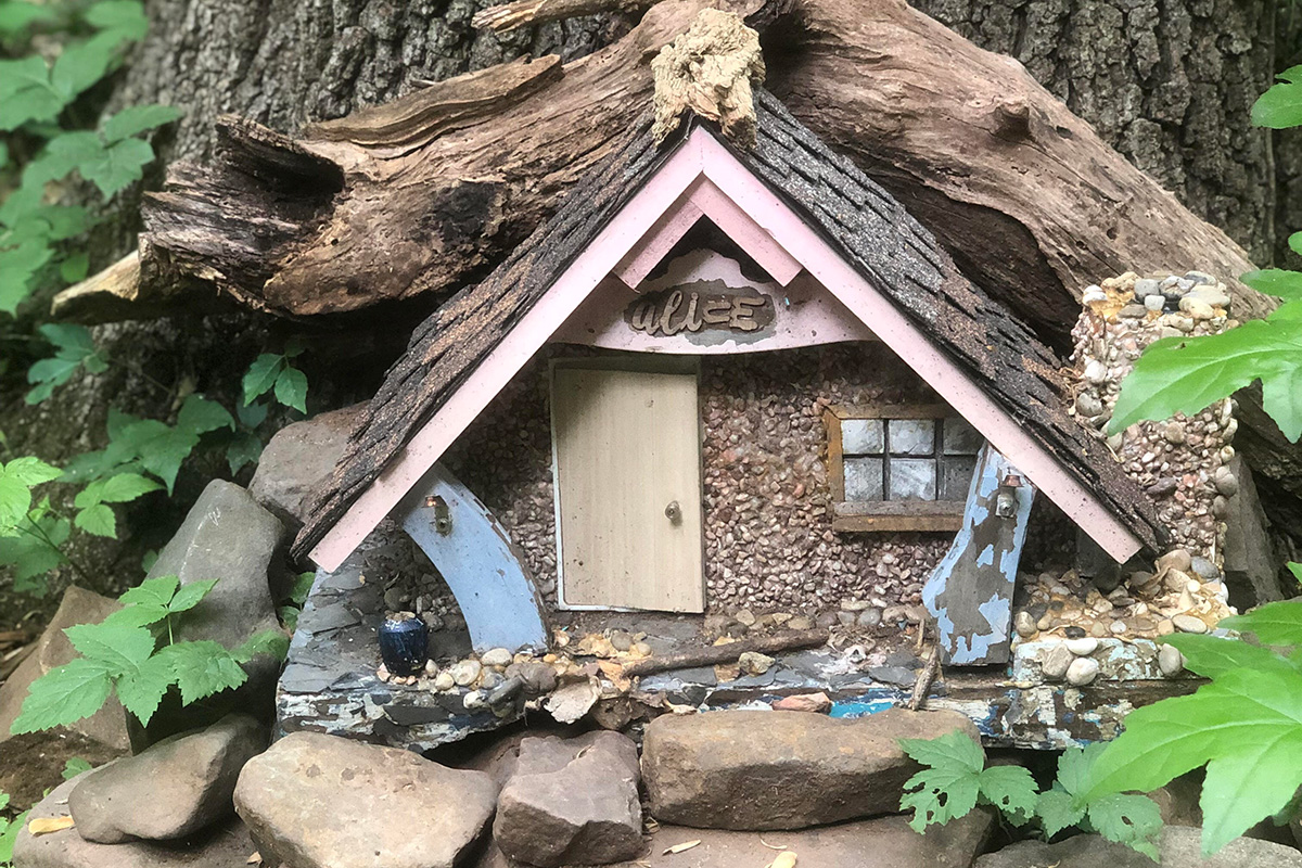
Waterfalls meet whimsy on the Hemlock Falls Trail and Fairy Trail at South Mountain Reservation, which is nestled between two ridges of the Watchung Mountains and covers 2,112 acres, with entrances in West Orange, Millburn, and Maplewood. There are six marked trails at the reservation, but Hemlock Falls Trail (1.2 miles out and back), and the Fairy Trail (1 mile out and back) are great for kids because they are short, easy, and offer some interesting sights. These two hikes can be done separately or combined for a more challenging 5.9-mile loop that’s still doable for kids.
Hemlock Falls Trail features a waterfall and a stream. During the winter, the falls sometimes freeze, making for stunning photo ops. The Fairy Trail has some magical surprises like miniature fairy houses with tiny ladders, doors, and furnishings. The abodes for Tinkerbell-sized inhabitants are the work of former New Jersey resident Therese Ojibway. All the houses are made from natural, biodegradable materials and can be a good prompt for story ideas. To combine these two trails, hikers should refer to a detailed map and use portions of the Rahway and Lenape trails.
Along the loop trail, hikers will see Washington Rock, located on a stretch of Crest Drive that is closed to traffic, which played an important part in the Revolutionary War. Known as Beacon Signal Station 9, it was one of 23 beacons built by General George Washington to observe British troop movements. For hikers who plan to do the hikes separately, it’s worth noting that there are two different trail entrances: for the Fairy Trail, use Locust Grove Parking Lot, 197 Glen Ave, Millburn; for Hemlock Falls, park at 64 Cherry Ln., West Orange.

For the Birders
Palmyra Cove Nature Park Loop, Palmyra
Rating: Easy
Distance: 2.1 miles
Elevation gain: 39 ft.
Accessibility: The loop trail is wide, unpaved and uneven in places, making it unsuitable for wheelchairs and strollers. The Environmental STEM Center is wheelchair-accessible.
This hidden gem is an urban oasis along a highly developed area on the Delaware River (across the river from Philadelphia) and is an outstanding birding site. It’s also a place where observation and technology come together to teach both young and old about the natural world, space exploration and conservancy.

There are 250 acres to explore, including one mile of beachfront, and an Environmental STEM Center open Monday through Friday. Spring is peak migration season, drawing hundreds of bird watchers to the park. More than 300 species of birds have been sighted at Palmyra Cove, but spring is the best time to spot warblers. These rare migratory birds sport plumage in an array of beautiful colors. Bald Eagles and ospreys are also frequently spotted overhead, and there’s a Peregrine Falcon nest on the Tacony-Palmyra Bridge with a bird cam that can be accessed online and in the Environmental STEM Center. There are two massive beaver lodges in the cove, which visitors can view from the park’s observation decks. Mink and river otters have also been spotted at the cove.
Washington Walked Here!
Rockhopper and Dry Run Creek Trails, Lambertville
Rating: Moderate to strenuous
Distance: 9 miles out and back
Elevation gain: 1,000 ft.
Accessibility: The unpaved trails are rocky, uneven and not wheelchair-accessible.
History comes to life on this trail once used by soldiers of General George Washington’s Continental Army. This hike begins beside the Delaware River in beautiful, historic Lambertville. A half-mile walk through the charming downtown area takes hikers to the beginning of the 9-mile, two-part hike and the entrance to the Rockhopper Trail. Along the wooded trail, under the shade of oak, beech, and sycamore trees, remnants of old stone walls and an old wood road call to mind the past. Washington’s soldiers reportedly traveled the route on the way to the Battle of Monmouth in 1778. At about the 3.2-mile mark, hikers need to cross Route 518 to get to the Dry Run Creek Trail. This part of the hike is hillier but less rocky, and is shorter at 1.3 miles.
The entire hike is on the longer side—plan to spend four to six hours on the trail—but by packing plenty of water and lunch it becomes more manageable, especially for younger kids. Howell Living History Farm is the halfway point, at about the 4.5-mile mark. With its shady trees and picnic tables, it’s an ideal location to take a break and have something to eat before turning back. Admission is free but, in the fall, there is a charge for the corn maze. The Visitor Center includes a gift shop and restrooms, and during warmer months, sheep, horses, pigs, and chickens roam the farm. A destination unto itself, the farm offers educational programs and demonstrates what working farms were like for visitors in the late 1800s and early 1900s.
From the farm, hikers retrace their route back to Lambertville. If all this sounds like a lot for the kids, you can walk along a section of the D&R Canal, which runs through Lambertville, for less strenuous family fun.
A Birder’s Paradise
Edwin B. Forsythe National Wildlife Refuge, Galloway
Rating: Easy
Distance: 5.3-mile loop
Elevation gain: 300 ft.
Accessibility: The trails through wetlands and woodlands are a mix of soft dirt and sand with some boardwalks. The Blue Trail portion of the 5.3-mile loop is wheelchair-accessible. The Akers Woodland Trail and Leeds Eco-Trail are entirely wheelchair-accessible.
There is plenty of hiking to be done at this wildlife refuge. This southern New Jersey coastal habitat comprises 48,000 acres. It extends 50 miles along the coast and through the back bays from Brick to Galloway. A birder’s paradise, it’s an important protected migratory route for birds and one of the largest breeding grounds for the endangered Piping Plover. There are resident swans, nesting osprey, ducks, wading birds, and Peregrine falcons. Deer, foxes, cottontail rabbits, box turtles, butterflies, and meadowlarks also call the refuge home.
First-time visitors should begin at the Visitor Information Center at 800 Great Creek Rd. in Galloway. From there, several trails can be combined for a 5.3-mile hiking loop, and there is an 8-mile-long self-guided Wildlife Drive auto tour. At $4 per car, the latter might be a starting point for an introduction to the salt marshes and wooded trails in this expansive refuge. The Visitor Information Center provides an insightful overview of the barrier islands and salt marshes, along with a film showcasing the birds at the refuge. To complete the 5.3-mile loop, which offers views of Atlantic City and a viewing platform and spotting scope at the Experimental Pool Overlook, begin at the Songbird Trail, which is well-marked and not far from the Visitor Information Center. Shorter options for this hike are the Leeds-Eco Trail (0.33 miles), where you can walk over a tidal marsh, and Akers Woodland Trail (0.4 miles). Both trails are wheelchair-accessible and kid-friendly and offer birding and beautiful views.
The Views!
Mount Tammany, Kittatinny Mountains, in Knowlton Township, Warren County
Rating: Challenging
Distance: 3.6-mile loop
Elevation gain: 1,526 ft.
Accessible: The 3.6-mile loop trail has rocky, uneven paths, with steep inclines, rock scrambles, and tree roots. It is not wheelchair-accessible.
The Mount Tammany Loop Trail is one of New Jersey’s quintessential hikes—and one of its toughest—but that doesn’t mean it’s not family-friendly. Bring plenty of water and snacks, wear sturdy hiking boots, find a good walking stick, and take it one section at a time. It’s worth it! The view from the summit is spectacular in every season but particularly stunning in the fall when the leaves are turning. From the top, hikers can take in sweeping views of the Delaware Water Gap, the Kittatinny and Pocono mountains, and Mount Minsi, another popular hiking spot across the Delaware River on the Pennsylvania side.
The most popular way to hike to the top and back is by taking the Red Dot Trail to ascend the mountain and the Blue Dot Trail to return. Both trails are rocky, and kids should be closely supervised throughout the entire hike, but the blue trail is a less challenging return route. Stay hydrated and take frequent breaks along the 3.6-mile loop. About 30 minutes into the hike, there is the first observation point. Expect to hike for another hour before reaching the top. An easier alternative to the summit hike is the Dunnfield Creek Trail, which runs along the creek and has a waterfall at the end.
Parking at the Dunnfield parking lot, which is on I-80 West just before the last exit in New Jersey, is limited, so it’s best to arrive early. After the hike, the kids might enjoy a stop at Hot Dog Johnny’s. It’s in the nearby town of Buttzville so be prepared for some giggles.

To the Lighthouse!
Island Beach State Park, Seaside Park
Rating: Easy to moderate
Distance: Eight trails, all 1 mile or less
Elevation gain: 200 ft.
Accessibility: Trails are flat and sandy. The Fisherman’s Walkway path (oceanside), and Tice’s Shoal Coastal Heritage Trail (bayside) have boardwalks and are wheelchair-accessible.
The 10 miles of undeveloped, pristine ocean and bayfront at the tip of the Barnegat Peninsula is a true New Jersey treasure. Every year, more than 1 million people visit Island Beach State Park, with most visitors flocking there in the summer months to swim and sun at the two public beaches, but it’s also a beautiful place to hike year-round. Osprey, foxes, warblers, wrens, sparrows, white and Great Blue Heron all make their home in and around the park. Beach plums, which bloom in the spring with pretty white flowers, are abundant (the park even hosts a Beach Plum Festival every September), and the pear cactus shares the same lovely bloom when in season.
There are a total of eight trails in the park’s Discovery Trail System. Signs posted along the route offer information about each habitat and make self-guided tours simple. Four trails in particular have a lot to offer families: Johnny Allen’s Cove Trail, Barnegat Inlet Trail, The Fisherman’s Walkway (oceanside), and Tice’s Shoal Coastal Heritage Trail (bayside). The latter are two halves of a wheelchair-accessible platform that extends in either direction from the main road. These trails can be accessed at Parking Area 7. Sand wheelchairs and those made especially for surf fishing are available at both Beach Pavilions during the summer and at the park office the rest of the year.
Johnny Allen’s Cove Trail is a 1.2-mile out-and-back route accessible from Parking Lot 16. The Barnegat Inlet Trail, located at the southernmost end of the park, begins at Parking Lot 23. From there, hikers travel down a paved road before walking along the sandy beach to the tip of the peninsula where the ocean meets the bay. Barnegat Lighthouse (Old Barney) can be seen across the bay on Long Beach Island.
—Jennifer Salvato Doktorski received a 2024 Fellowship from the New Jersey State Council on the Arts. A proud mom and Jersey Girl, she’s the author of five young adult novels and lives with her family in Central NJ. Learn more at jendoktorski.com.
Get the latest on the best things to do with your family in and around New Jersey by signing up for our newsletter and following us on Pinterest, Facebook and Instagram!
Read More:
6 Unforgettable Outdoor Adventures to Take in NJ This Spring
These Are the Best Towns in New Jersey to Raise a Family in 2025, According to Niche
The Best Waterfalls in New Jersey – Where to Go Near You
These Charming New Jersey Towns Will Make You Feel Like You’re Traveling Abroad
